
The Via degli Inferi and the Cerveteri Necropolis

Premise: This tour is divided into two distinct parts, one mountain bike and one on foot. It is an easy route and suitable for anyone, including families with children. The location of the tour is within a UNESCO site
Description: The tour starts from the parking area designated for the "necropolis of Banditaccia" at Cerveteri.
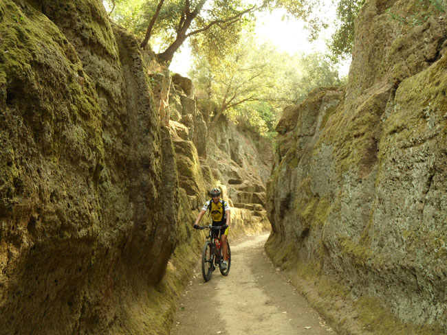
It will take only a few meters to understand that we have entered a special place and that our bikes will be advantageous for us to discover the splendid burial complex located in this unique natural environment were art and nature mingle, where nature is a real part of the monuments, and the monuments blend into nature. Just as soon as our eyes have grown accustomed to the wonders that surround us we are again amazed when we find ourselves on the so-called "Way of the Underworld ". Here it is needless to describe all that is there waiting to surprise you.
The excursion continues, after passing a small hill which we will walk up pushing our bikes by hand (just a few meters). Then on a smooth dirt road the scenery changes dramatically. We are now in an open environment where the wood skirts along the mountains and where a meeting with the herds of Maremma cattle is probable. In short flash we will actually go through a forest of oaks subject to targeted felling demonstrationg the needs of man being met by the careful management of nature. After a few more kilometers we come to an clearing where we can leave the bikes. From this point begins the part of excursion which entails a bit of hiking, which be it simple will also be satisfying. We walk along an ancient Etruscan-Roman road which continued to be used throughout the Medieval era. At places the tuff stone has been carved through and it is almost impossible not to let your mind wander as we follow this age old route that linked Cerveteri with Castel Giuliano.
Our meandering in the woods will take us to a Roman bridge called the“Austriaci” (Austrians) which helped and still helps us today to cross a small stream that feeds the Vaccina river which is full of so many waterfalls that in fact we visit this area on yet another scheduled excursion (Sasso-Castel Giuliano Waterfalls).
Slowly we make our way back the same way we had come and after we retake our bikes we will follow a dirt track until we reach the Roman road which traces the ancient walls of Cerveteri. In a flash we are in the precious historic center. The fortress, the beautiful square with the church of Santa Maria Maggiore, and the houses all maintain the charm of this small medieval treasure. After we have a look at the sea in the distance from the ramparts of the ancient walls we can relish the traditional delicacies from the local cuisine. Then a quick ride towards the end of the excursion. At this point we can decide to take advantage of what is maybe the most spectacular part of the excursion and visit the very well preserved necropolis of Cerveteri.
Technical Specifications: Length of the cycling route is around 16km. Length of hiking trail is 1km. Total uphill ascent is 350 meters. The time allocated for the excursion is 3h (excluding the visit to the necropolis)
We await you for a good fun ride

Easy
The Treja Valley and Calcata


Premise: This excursion, unlike almost all of those I propose, takes place virtually travelling back and forth between two villages, Campagnano and Calcata. I can assure you that the scenarios offered in both directions will surely surprise you.
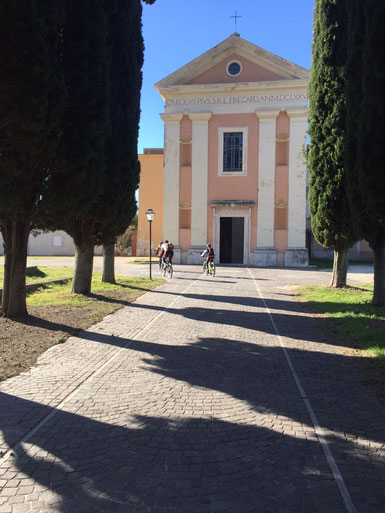
Description: We start from the small town of Campagnano Romano going through the monumental walled gate that gives access to the historic center (closed to traffic). We follow the road that after a while will offer us the opportunity of traveling a long stretch of the Via Francigena. We enter the Park of Veii which claims Treja Valley as one of its true gems (also a designated park in itself) The road descends steeply down from the village but on practically perfect asphalt. We follow the road that follows the valley and after the first few kilometers passing old farmhouses we begin a series of ups and downs alternating between off road and asphalt stretches. A short climb and we are on top of a hill. The view is magnificent, Mount Soratte stands out as an island on the Tiber plain; we see the ravines that radiate from the Valley of Treja and in the background the Sabina and Lucretili mountains.
We begin to make our way down but after a bend where we catch sight of a stair that cuts, straight, between steep rocks. It is an invitation that we accept that brings us to a small but striking Etruscan necropolis. Through the branches of majestic trees, we can see our next destination the small village of Calcata. We leave an easy going dirt road to follow the wildest part of our journey in the park. We find ourselves on the edge of a ravine protected by a handrail so we proceed slowly, enjoying the spectacular show as we go down. Reaching the stream (one of the many that flow into the Treja) we follow the path until we reach the main road. We start to climb and soon we come to the real marvel of our tour, Calcata a medieval village virtually intact.
A little square welcomes us and we note a church dedicated to the SS. Name of Jesus. Curiosity drives us to lose ourselves in the tiny alleys with small shops where the view over the valley of Treia is an unforgettable must. Ready now to return to Campagnano we ignore the first little trail and go on to find a good dirt road that follows the Via Francigena. Along the way we come across the "Temple of Mount Saints". We wind around the hill to retrace the route we had taken on the first leg of the trip but this time we discover the landscape from another angle with a changed perspective.
And now where are we now? This will probably be your reaction when, after a little hill, we are catapulted into the roar of the challenge against the clock, of the drivers racing around the Vallelunga circuit named Taruffi. I know, someone will turn up his nose, but when you see a beautiful curve it will be very difficult not to pause and wait to watch a few fast moving cars tackle those stretches traveling at their limit. We are now at the end of our excursion, a journey that has provoked in us so much emotion and so in reaching this goal I dare say we have united art, history, and nature, while practicing sport.
Technical Specifications: The length of the tour is 30 km, with a total height gain of 500 m. and a stretch of route with an obligatory tract that necessitates taking due caution. This excursion is a great opportunity for those wishing to climb a rung on the scale of difficulties and thus open a whole new series of possible excursions.
We await you for a good fun ride


Average Effort
Ninfa-La Via Francigena: The former Roma Terracina railway


Premise: The route is suitable for everyone and offers an excellent example of what the bike can render possible. To reach the point of departure just take the motorway Rome-Naples and exit at Valmontone. Turn left and follow the signs for Artena, Giulianello and Cori.
Description: Heading off from Cori, a hill top village which houses the remains of a temple dedicated to Hercules at its higher reaches, we gain a great panorama of the sea, Mount Artemisio, with the Lepine mountains, Norma and the promontory of Circeo on one side, and on the other Velletri with the lower slopes of the volcanic crater which gave birth to Lake Nemi within the Castelli Romani park. Just a few hundred meters on as we ride along a well paved street, surrounded by olive groves and vineyards we will be projected into a framework of wonderful Mediterranean colors and smells. Depending on the season we might be lucky enough to catch the harvest of olives or grapes and their characteristic scents, the must from the wine cellars or the sweet fragrance of the mills pressing the olive for oil. On this road we roll along quickly following the old canals that run beside the Via Francigena. The eye is captured by Norma that seems to be almost hanging from the rock face over shadowing the Oasis at Ninfa. The visit to these gardens, with its Medieval tower, pond and fresh springs is a must. Once again pedaling we continue over hilly terrain, sweet to eye as lovely companions along our way. Our return for a part, will be on the old disused railway that connected Rome to Terracina. With a short climb we find ourselves once again just below Cori along the provincial road which for the last few hundred meters completes this pleasant circuit to where we had begun.
Technical Specifications: The length of the tour is 30 km. The maximum height gain is 350m with the highest elevation reached at 270m renders this trip suitable for everyone.
We await you for a good fun ride

Easy
L’Ara della Regina – Tarquinia

Premise: When you finish this tour you will come to understand why Tarquinia is one of the most beautiful and best preserved cities of Tuscia
Description: The excursion starts from a convenient car park situated near the massive walls of Tarquinia just a few hundred meters from the historic center. With the immensity of this breath taking monument which completely surrounds the city in full view we begin pedaling passed Tarquinia’s medieval buildings. One of these is the beautiful museum that jealously guards the relics found in the necropolis and the archaeological site which is our tour’s destination: the Ara della Regina.
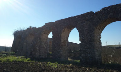
Only a short way, after passing through an ancient gate, we find the wonderful Romanesque church of Santa Maria in Castello completed in 1207. At its side rises Tarquinia’s tallest tower to complete this picturesque scene. With hardly the time to turn our heads we find still another magnificent gate with its guard tower. Back on the bike and in only one hundred meters we can not but admire the so-called new fountain which dates back to the second half of the thirteenth century. After so much beauty we let our selves fall into a fun descent that takes us down into the valley where runs the river Marta. Here the emissary of Lake Bolsena has its last course before emptying into the sea. Unfortunately some disused buildings as well as an old military base spoil the scenary but fortunately not for long. Just a few kilometers ahead the Maremma gives us the best of itself. After a small ford we face the first real obstacle of the tour, a tough climb that we will tackle slowly eventually forcing us to push the bike by hand. At the top of this stretch (about 100 meters) we will be rewarded with a stunning panoramic view. The dirt road ahead is pleasant and after pedaling leisurely through wheat fields we enter a dense forest of oak trees. We are at about 280 m. above sea level and after some quick ups and downs we exit out from under the trees and onto S.S. 1 Bis. No more than one kilometer further on, we come across the beautiful symphony of eighteenth-century aqueduct arches. We begin here to follow a comfortable dirt road that leads to Ara della Regina. This Etruscan temple dedicated to a deity, probably attributable to "Diana" is the most important find in Tarquinia. After visiting the site we head off, following the gentle hills, towards the modern city. Once we get below the village we confront the second and final difficulty of the excursion, a one kilometer climb which we will face very, very, calmly! The gradient can be from 10% to 20% but at its end is a medieval gate welcoming us back into the city. After wandering in the oldest and most precious part of the city we are at the epilogue of this pleasant tour.
Technical Specifications: The excursion is approximately 28 km. The maximum height reached is about 280 meters but the total uphill climbing reaches 500 meters. This data, however, is misleading since there are no technical descents and the two climbs are long and steady uphills which deems this circuit to be classified of medium difficulty.
We await you for a good fun ride


Average Effort
The Tour of San Vittorino

Premise: A very rewarding tour that does not change the spirit of " Lazio Tours " but in this case highlights the sporting aspect.
Description: We begin our tour in the square of S. Vittorino, a small village which is part of the municipality of Rome, where the Barberini Castle is there to welcome us. As soon as we begin to pedal we are immediately thrown into the Roman countryside. Riding on a tuff ridge we can see to our right the gorge carved by the small stream that flows below the village.
The land immediately alternates, one minute cultivated fields, the next olive groves and then forests. On a dirt road we proceed fast and after a while we come across a beautiful country house with an ancient wood-burning oven integrally part of the structure, giving us a wonderful example of how, even today, man with a little effort and much passion can bakes his own bread in complete autonomy and consume the fruit of his own labour. We continue past olive groves and through a sudden patch, which is usually muddy, heading straight toward Tivoli. The dirt road is fun and very scenic. We enter for a quick bit in the town paying careful attention to the traffic and then head straight out again following the course of the Aniene river. After going through a wonderful Roman gate we speed toward the hardest part of our journey. The road is paved and almost devoid of traffic, but the going is a tough climb, (from 10% to 18% gradient). At first we might have turned up our noses at seeing asphalt ahead, but as we go on, we gradually come to accept it with pleasure! Climbing and still more climbing is what lies ahead, but suddenly it is over and the view of the Catillo, and Lucretili mountain ranges takes what is left of our breath away.
By the time we arrive at the monastery of Santa Maria another break is a must and the views of the mountains of Prenestina are really rewarding. From here we see our next destination, St. Gregory da Sassola, with its castle. We quickly reach the road that skirts along mount Carella and curiosity will surely drive us to enter a small village which lies on a volcanic bed. Continuing our journey we pass a few olive presses with their unique scent perfuming the air. Now we head uphill onto a narrow road which soon becomes a dirt road. We proceed along being careful when we get immersed in a magnificent olive grove. This tract is very varied and lots of fun but we have to pay careful attention. One point in particular which descends with deep cut ruts along the way demands cautious attention. We go quickly down and after a short path we have completed our trip, arriving again at the starting point of this tour, rich in artistic and natural gems, but where the sport activity is the real protagonist.
Specifications: The length of the trip is about 25 km, with a minimum elevation of about 150 meters and a maximum of 555mt. The total altitude gain is 600 meters but one must not be deceived! This excursion is challenging; remember it is how steep a climb is that makes it difficult.
We await you for a good fun ride


Strong Effort
Monte Piantangeli


Premise: This is one of the excursions where it is not so important to check the level of difficulty. Each and every one of us will be impressed and amazed favorably to experience the very heart of Tolfa.
Getting there: After taking the road from Civitavecchia to Allumiere we leave our car in a comfortable open space shortly after the road turns of for the little town of " La Bianca ".
Description: The route starts immediately with a quick climb to warm up our legs which we will attack calmly since our muscles are still cold and stiff. After a few hundred meters on asphalt we enter into a nice Beech wood and a good dirt road. A little further on we leave the forest, taking care as we cross the trafficked road which leads to Tolfa.
We continue along a not so busy road with a bit of ups and downs that soon will bring us to a dirt road. We plunge back into a wood of stout Turkey Oaks which are subject to sustainable felling. The path is easy and pleasant, though a little hilly, alternating with short descents. Suddenly we arrive at an clearing which allows us to catch a view of the vast plain below, topped by the Tolfa fortress which we can not help but admire in its seemingly audacity perched like an eagle above the town. A few meters on and we find ourselves at the foot of the remains of an Etruscan-Roman temple called "Grasceta di Cavallari". The place is full of charm revealing all its spirituality as witnessed by the presence of Convents and Shrines but we are headed for an almost more magical place where the presence of the Templars and their tragic end seems to be exemplified.
Leaving the wood, after a last hill, we enter one of the archaeological sites which is least known in Lazio. On the plateau of "Monte Piantangeli" we can find the remains of an ancient Romanesque abbey, founded in the Carolingian period (XIII sec.), a medieval town and some Etruscan tombs. Leisurely pedalling among the ruins, we can pivk out a baptismal font, an altar and some mighty columns. The site is at the top of the mountain about 510 m.a.s.l. and the view on the Mignone river valley and a good part of the Tolfa foothills is breathtaking. The Rota, the castle in Bracciano, and the village of Tolfa are all in view with the Apennine massifs as a backdrop.
After admiring this eighteenth-century framework we return retracing much of our tracks but this time we will stop to taste the fruit of the strawberry tree, a real treat waiting to be discovered. We pass through Allumiere and then soon after we are at the starting point of this easy, but hard to forget tour.
Technical Specifications: The ride is about 27 km long. The starting point is about 498 m.a.s.l.. The highest point is at 598m, and our destination is 510 m. This indicates that we will not encounter kilometre long climbs but many short ups and downs with a total elevation gain of about 560 meters.
We await you for a good fun ride

Easy


![]() 2016 Lelio Mario Libotte
LBTLMR68L30H501M
2016 Lelio Mario Libotte
LBTLMR68L30H501M