
Sasso - Castel Giuliano Waterfalls


This excursion starts from the village of Castel del Sasso or just simply Sasso, a small fraction of Cerveteri. It is medieval treasure, surrounded by crenellated walls that enclose the ancient town center with the small church of Santa Croce in Sasso and a castle, ancient home of the Marquis Patrizi. After leaving the town on a short paved section, we enter the old road to Castel Giuliano. This, after a few hundred meters, becomes a dirt road, running through olive groves and wheat fields, dominated by beautiful oak forested mountains. After taking a fork in the road we eventually will come to an ancient bridge which signals our destination, the Castel Giuliano waterfall. Of course there is always the possibility of a dip in the cool pond of the waterfall for the strong-hearted and willing.
Technical characteristics: the route starts at Sasso (310 mt. s.l. m.) and continues approximately for 30 km over a gentle up and down hilly course which is never too exhausting. It is not a very difficult route except for two short climbs which will be taken carefully and in stride.
We await you for a good fun ride

Easy
Manziana Forest- Caldara- Castel Giuliano


An easy excursion to introduce those new to mountain biking to the activity. A great location full of historical interest absorbed in a natural, charming setting.
Description: The tour starts on a dirt road in the Manziana Forest with its magnificent, stately oaks that stand guard all along the entire length the path. After a short stretch on a country lane we enter the Regional Natural Monument of the Caldara of Manziana. After having visited the caldara, we will ride a short section of the provincial road that connects the village of Sasso to Manziana. Then on an ancient dirt road we will continue through olive groves, wheat fields and oak woods to the small village of Castel Giuliano which is set in a hilly landscape dominated by the mountains in the background.
The return to Manziana will be by means of small roads and a trail that offers the added emotion of fording a small river.
Technical Specifications: The length of the trip is about 30 km with a single soft descent that will be confronted carefully. The climbs to be tackled are short and never to strenuous.
We await you for a good fun ride

Easy
Great Loop around Tolfa and variant
Premise: This excursion is for those who already have experience mountain biking and who have a good level of training. There is always the possibility of shortening the circuit to exclude the last demanding part of the trip, making the excursion more accessible to all.
Description: A tour that offers great satisfaction. We begin in a soft, pleasant manner. After crossing a bridge over the river Mignone a dirt road in good condition starts immediately climbing, and then after an easy up and down stretch we arrive at our first stop, the charming Civitella Cesi. From here, we follow a paved road along a short stretch that traces an ancient Etruscan way until we come to the archaeological site of San Giovenale, characterized by medieval castle and ancient Etruscan houses that adjoin a ceremonial burial ground. From this point, the complete or “integral” itinerary, continues by following the route of an old railway which leads towards Civitavecchia. While the “easy” route returns following the same outward bound route back to the start.
Just after crossing a bridge over the river Mignone, which offers beautiful views of the natural protected area, we will need the help of headlamps to go through two abandoned train tunnels where we must proceed with caution, one of the tunnels is rather long and very dark. Then following a dirt road parallel to the railway track we come to the old Allumiere train station. From here a paved road will take us first to the Farnesiana deconsecrated church, now under restoration, and then we will ride on to Allumiere. In this stretch there is a decidedly long, steep climb to be reckoned with which, after travelling more than 35 km on dirt roads, demands considerable effort. From Allumiere we follow the provincial road that will bring us first to Tolfa, with its splendid views of the valley below and then the Fortress of Frangipane that overlooks the town. Then off, on one long thrilling descent we will arrive at our starting point which offers one last romantic look at the Rota.
Technical Specifications: The length of the trip is about 48 km generally on dirt roads which are in good condition. The climb up to Allumiere, though on asphalt, does its part to assure that this challenging loop takes all of its five hours to complete. For the integral complete itinerary the use of a headlamp is necessary.
The shorter variant must not be taken for granted as the expected duration is about four hours but with a much reduced amount of climbing. Only the first, not so difficult climb must be confronted on this variation.
We await you for a good fun ride


Strong Effort
A Loop around Vico Lake

Description: The route which takes proper advantage of what mountain biking is all about is almost entirely in the Natural Reserve of Lake Vico. This enchanting excursion freely presents stunning panaromic veiws from the vantage point of the hills which surround this pristine pure lake. For bird watchers there is the extra added bonus in the possibility of using the various stations placed in opportune positions to observe the rich avifauna.
The tour starts from the parking lot near the restaurant "La Bella Venere" on an asphalt road. Immediately turning our gaze to the shores of the lake our attention is captured by the groves of hazelnuts and chestnuts that grow to excellence in this area. After a short distance there is the first possibility to use one of the huts specifically placed for the observation of the large birds (marsh hawk, kestrel, buzzard, heron, coot, mallard) that make their home in the wet land area of the reserve.
Back on our bikes, a dirt path crosses the lake shore area of reed beds and we continue on the road that circumnavigates the lake. As we proceed, the groves of cultivated trees give way more and more to park wood which consists of oak, beech and lovely wild chestnut trees. At a crossroads, we take the road that climbs abruptly towards the Cassia, engulfed by the shade of the forest. We continue, proceeding well on a dirt road which is usually always in good condition, even after a heavy rains. Finally we wind our way to the top of Mount Fogliano. Still in the woods, we go along easily until suddenly there is a very enjoyable downhill tract which with a brief pedal or two will bring us to an asphalt road and then to a crossroad. Continuing on a fine dirt road with a bit of up and down we travel across the hillside. When the trees begin to thin out, giving way to a full panorama we must make a stop to take in the magnificence of the view. The dirt path now begins to beat a bit strong; its rough surface leads us towards the slopes of Mount Venus where we cross the final stretch of asphalt that leads back to our starting point.
Technical Specifications: The length of the loop is 30 km. With a maximum altitude gain of 700 meters. Mount Fogliano being the maximum elevation at 965m.sl.
The mountain bike is one of the most suitable means of getting around a natural reserve; It allows you to reach many points of interest all in the same day without leaving anything behind but a few bare tire tracks. The main difficulties lie in the climb on asphalt and on the dirt path up to Mount Fogliano, and than the last down hill to Mount Venus. The first will be approached slowly, without sudden rushing, just taking it easy and enjoying the beautiful forest that surrounds us. The second is to be carefully assessed, not hesitating to get off and continue prudently pushing the bike by hand (Remember we are not here to compete!). Remember always to give priority to walkers, as they often can be encountered travelling stretches of the marked trails in the nature reserve.
We await you for a good fun ride


Average Effort
S.Marinella- Tolfa Mountains


Premise: This trip can start from two points. One with the use of private vehicle, can start from a parking lot just after the junction of the A12 (exit Tolfa) and the other by train can start from Santa Marinella Railway Station.
Description: Despite which of the two starting options is chosen each has its own real beginning in Santa Marinella since the stretch of the Aurelia state road which could offer a quick look at the stunning Santa Severa Castle can be considered either a prologue to warm up with or final cool-down. The castle is well worth a visit. This is an itinerary dedicated to lovers of nature that offers the opportunity to appreciate the beauty of this particular area of our region.
We immediately begin climbing in the direction of Allumiere on paved road that will help us to gain altitude a little more quickly given the not so insignificant difference in altitude we will have to reckon with in total. When we come to a dirt road, you certainly will feel thrown into the setting of a Western film, one where it is likely to meet grazing herds of beautiful Maremma cattle and all but wild horses, while ever present is the sea in the background and the Tolfa mountains lying ahead to where we dare to arrive.
We will continue to climb, encountering scattered oak woods and vast skies where the eye will lose itself following the flight of the Short-toed Eagle. The dirt road then becomes paved for the last stretch which leads right up to mount Tolfaccia. After a short levelling out over a flat section we will begin a descent into an oak wood on a dirt path that at first will be easy but then, because of the presence of loose stones, will cause us to exercise due caution.
Our journey will continue downhill in a natural, uncontaminated setting, giving us the thrill of tackling, in quick succession, three fords. The tour here comes to an end now along the beautiful road which leads from Tolfa and which soon will take us to our starting point. If we have arrived by train we will take the Aurelia state road back to the Santa Marinella Railway Station.
Technical Specifications: The length of the ride is about 40 km with. 80% on country lanes and dirt roads in good condition. The climb from Santa Marinella has to be dealt with without excessive overdoing, always at a calm pace because even though the maximum quota to be reached is 516 m.s.l. and the ride is short, it still involves a total altitude gain of 800 meters!
Care must be taken, because the descents are on uneven ground with loose stones while a part of the descent enters the provincial Tolfa to Santa Severa road. The Aurelia state road will naturally be travelled carefully making use of the wide lateral shoulder. The journey time is about four to five hours.
We await you for a good fun ride


Strong Effort
A Loop around Tusculum


Premise: This excursion is for those who already have experience mountain biking and who have a good level of training.
Description: This tour begins amidst the beautiful ruins of the ancient Tusculum from where we can get a panoramic preview of the beautiful places that will be visited along our way: Rocca di Papa, Rocca Priora, and the vast the meadows of Vivaro. Immediately after, we must pay careful attention to a short steep descent on a path that will lead us on to a more relaxing dirt road. After a series of short ups and downs traversing Mount Solomon we will reach Rocca Priora.
After a quick spin through the town, their is a fast descent on an asphalt road and then a short stretch actually on a section of the ancient Via Tuscolana. Then pedalling a bit on paved roads we will eventually find a dirt trail in good condition which will take us up to Rocca di Papa. The stretch of asphalt winds through a very pleasant wood. Once we reach Rocca di Papa we will continue on and across the legendary fields where Hannibal supposedly camped, the Campi di Annibale, riding on an easy off road path surrounded by chestnut trees.
Rolling on, surrounded by the lush greenery the kilometres will pass quickly over a series of ups and downs which lead to a steep descent made complicated by the encrusted hoove tracks caused by the passage of horses. Never hesitating to proceed on foot pushing the bike by hand for the most difficult sections, we are reminded that we are not racing and here to take in the natural beauty of the place at a safe pace. Finally we will reach the source of Franoa spring but unfortunately the water is not drinkable. Now the route becomes easier and after leaving the dirt road and riding a short distance again on Via Tuscolana, we will reach the last leg of the tour, an all uphill climb up to Mount Tusculum where we will find our point of departure.
Technical Specifications: The ride starts from the ruins of Tusculum at 670 msl. and entails about 30 km of riding but with some pretty tough climbs and technical descents so we consider a half day necessary to allow for the necessary calm to render this challenging tour safe and enjoyable.
We await you for a good fun ride


Strong Effort
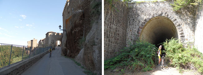
On the trail of the "Marchese del Grillo" - Canale Monterano


Premise: This excursion takes place almost entirely in the Canale Monterano Nature Reserve. To take fullest advantage of this natural treasure we have divided the itinerary into two distinct gems, one dedicated to a mountain bike ride and the other a hike along the walking path.
Description: The trip starts from the small town of Canale Monterano and has two destnations: the ruins of old Monterano and Diosilla waterfall.
The first can be reached by the mountain bike with an initial stretch on asphalt with a some up and down bits. The climbs are not to be under estimated but will to be tackled in a relaxed manner with very low gears while the downhill is on an easy dirt road.
After a brief ride we come to the ruins of old Monterano with its lost city charm, and though abandoned, so rich in history with its Bernini fountain, a real architectural jewel. This was the site chosen to shoot one of the most unforgettable scenes, in the classic film "the Marchese del Grillo." After visiting the site we leave our bikes and head off on foot towards the Diosilla waterfall which we will reach in about a half an hours walk. The natural scenery along the path here will seem to be in competion with those works by man which we have just seen, one more wonderful than the next, to impress the eye, none less impressive than the wonder of the solfatara! Returning to our bikes we head towards the town of Oriolo, turning off on to a road with panoramic views that will take us to back our point of departure.
Technical Specifications: The total duration of the trip is about three and a half hours. Though the riding distance is no more than 15 km it has some climbs and descents and to be confronted with care. The walking trail takes about an hour and a half and includes an descent that must be confronted on the way back following the same advice given for bike trip.
We await you for a enjoyable and fascinating trip

Easy
Subiaco and the Benedictine Monasteries


Premise: the ride is easy but intended for those who already have experience mountain biking and who have a good level of training. Often, it is true that increased effort is repaid with rewards that exceed expectations.
Description: the departure is from Subiaco which welcomes us with its triumphal arch where we will leave the car in a small square. The initial stretch on asphalt, introduces us immediately to the upper course of the river Aniene where we are then greeted by the Emperor Nero, who erected one of his villas on this site. Our attention is soon captivated by the Affilani and Simbruini mountains, so rich in unspoilt nature, with panoramic views that helps us to understand quickly the mystical charm of this place and to understanding fully why it was chosen for the location of the two monasteries, one dedicated to St. Benedict and the other to St. Scholastica, our final destination.
We leave the narrow paved road and continue on an easy dirt road that follows the course of river Aniene like an admirable artist that traces the sinuous lines of the valley upon contact.
Our eyes wander from the slopes of the lush green mountains, Mt. Cross (1158 m) and Mt. Pianezze (1332 m), and then back to the cheerful flow of the river. At one point, we will cross the Aniene, over a bridge that seems to take us back to a time when these scenarios were the norm.
Over head, to the left is situated the medieval village of Jenne perched at the top of a mountain at 848msl, a vigilant sentinel and the coveted goal of our trip.
We continue up to the end of the dirt road and leave the river behind, taking with a certain awe, the paved road that leads up to the village but which can be pedalled with a determined will. Finding the climb not as daunting as it first seemed we will begin to enjoy the woods all around us and catch the possibility of different perspective to view the beautiful valley and the surrounding landscape from. After a short spin around Jenne, we will launch ourselves into the fun descent, which must be conducted carefully, slowing down when taking curves and passing through small tunnels. Shortly we will be at the gates of the beautiful monasteries with the possibility of visiting them. Once we again begin our descent, it will be one continuous down hill all the way down to the end of our trip which we will be reached in a very short flash. The broad smile printed across our faces in exhilaration will be very difficult to remove.
Technical Specifications: The distance of the journey will be about 33 km with an altitude gain of 500 m and an estimated time of four hours. Even if the cold figures seem to indicate that we are facing a trip with easily conquered climbs on more easy going asphalt and the stretch of dirt road is in good condition along the Aniene, free of danger, we still should not underestimate this trip. Considering the physical effort and a visit to the monasteries the better half of a day is necessary to render this excursion enjoyable.
We await you for a stimulating and rewarding trip


Average Effort
The Lakes around Percile


Premise: if you love mountain biking then this excursion will be the one you have always dreamed of. It is intended for those who regularly go mountain biking and so are relatively fit. The starting point is in the large parking area across the Tiburtina Valeria from the Vicovaro Mandela railway station which offers the possibility of using the train to arrive for those who wish.
Description: We will head off for Cineto Romano where after a short pedal along the Tiburtina Valeria we will reach the Regional Park of Monti Lucretili. Here the asphalt gives way to a good dirt road as we pass gorgeous scenery and an amazing nature. The park is home to the golden eagle and the wolf, and in 1998 the presence of a Marsicano brown bear was also recorded here.
In the first stages of the climb we pass mostly through a wooded area typical of the Mediterranean chaparral trying always to focus our attention on the path ahead which in sections can sometimes prove difficult difficult. I remind you that we are not in a race, so there is plenty of good reason to enjoy the magnificent views.
After reaching a mountain pass we face our first stretch of steep descent and after a few bends we can relax and take in the splendid mixed forests of oak and beech trees riding easily towards the stunning Percile lake surrounded by a typical birch forest. (There are two lakes but the smallest is hidden from view by dense vegetation)
My advice is to make this trip in the fall when the park is tinged with a thousand blazing autumn colors and the calm waters of the lake reflect the priceless natural setting.
Reluctantly we must move on continuing on our way to the village of Percile which welcomes us with the lovely little church of S. Anatolia.
We then follow the beautiful valley along the License torrent which gives its name to the road we are traveling on (via Licinese) and after passing the village of Licenza we will soon reach the ancient villa of the Latin poet Horace. His descriptions not only allowed the correct attribution of the villa but equally facilitated the excavation of the area by the Superintendency. This last pearl amongst many from this wonderful tour will long remain in our minds and I know firsthand it will help to cope better with the tiresome week ahead as we wait for the next mountain bike excursion.
Technical Specifications: the starting point is from the parking area across from Vicovaro Mandela Railway Station at about 300 m. The mountain pass which is the highest point of the excursion is 900 m. These are the two significant figures to be taken in consideration when evaluating the physical commitment needed to confront this excursion always keeping in mind that a good workout often reaps the best rewards life has to offer. There are not many particular difficulties in managing the off road conditions you will meet, except for a few places. By in large the way is in good condition and amply large. The distance approaches 30 km which can be basically divided into two segments: an outgoing climb up to the pass, and then the return, a long continual descent, which, except for a few short spells, leads back to the point of departure.
Getting there: By private car I recommend taking the A24. Exit at Vicovaro Mandela and follow the Tiburtina Valeria for a short distance towards Subiaco. You will arrive at the parking lot (on the left) across from the train station.
We await you for a enjoyable and fascinating trip


Strong Effort
Discovering Martignano Lake


Description: The excursion starts from a parking lot near the church of S.S. Trinity in Anguillara, on an asphat road. That we head straight for the Bracciano and Martignano Natural Park hints at the real aim of this excursion: to get to know every angle of this little known park, while putting its wonderful scenery in perspective.
On the dirt roads that climb the hills of the Sabatini mountains we are quickly put to the test but even without too much hurry we find ourselves almost immediately at 326 m.a.s.l. in front of a lovely panoramic view characterized by the craters of ancient volcanoes, today's lakes, Martignano and Bracciano. After a short but thrilling, descent we find ourselves traveling again between the rock cliffs in a gateway cut out of the tufa by man many years ago. The oaks, rimming its edges, dramatically demonstrate to us how these magnificent natural sculptures cling on to life. Shortly we reach a terrace where we can enjoy a magnificent view of Martignano lake.
Once again on an easy dirt road, we gain the crest of the crater where the view of Bracciano lake and its surrounding villiages, Anguillara, Bracciano and Manziana will carry you off beyond the horizon. A narrow road crosses olive groves and fields with a few curves to add fun to the descent and then we reach the junction where an asphalt road that runs all around Lake Bracciano will ease the pedaling and make faster progress towards the end of the tour. But not too soon! There still is Anguillara with its distinctive tower, and historic center mirrored on the calm water of the lake to give an ultimate feeling of satisfaction.
Technical features: The excursion is to be considered suitable for all since the distance is miminal, only 25 km. The lowest height is 130 m and the highest to be achieved is 326m.a.s.l. with an overall height difference of about 320 m. The mountain bike is the most suitable means of making " tracks" through the park, allowing us to reach many sights otherwise too far to reach while at the same time permitting us to visit an ancient town on Bracciano Lake which is closed to traffic. The main difficulties lie in the series of uncomfortable bumps which we encounter in the first part of the trip. Most simply, these can be addressed slowly or, leaving to personal judgment, the decision to walk the bike over this area as always an option.
Getting there : Private car: SS2 Via Cassia in the direction of Viterbo. Train to Viterbo from Rome Ostiense station, Rome Trastevere, Rome St. Peter. Stopping at Anguillara.
Overnight accommodation: B&B I Gatti del Castello Bracciano
We await you for a enjoyable and fascinating trip

Easy
Following the footsteps of St. Francis and the Via Francigena in Veio Park

Description: Having past the village of Formello the provincial road provides ample space for parking. Leaving from here, after only a few hundred meters we dive immediately into the embrace of Veii Natural Park which welcomes us with the its tall, stout oaks.
The dirt road is easy and fun. We will momentarily leave the thick woods for an open clearing, where suddenly, we gain a great overlook of Rome. Once back in the woods a short tough climb will entail pushing the hand-bike for a few meters, but with another impressive panorama awaiting us at the top. Another short stretch and we come across Sacrofano which we will pass quickly in its bucolic setting.
Ahead it is possible to find horses and cattle grazing freely which sometimes stop to drink from a beautiful old fountain which we will pass. Overcoming alternating stretches of asphalt with off road dirt and gravel conditions you will surely gain appreciation of the mountain bike and the advantages it offers on such terrain. In a flash we find ourselves on a stretch of the historic Via Francigena, an ancient road used by pilgrims coming to Rome since medieval times which will lead us to the small but very beautiful Sanctuary of the Madonna del Sorbo.
Here the Cremera river and its valley characterize this part of the park which we will be traveling through. With a small deviation we reach a little but spectacular water fall with a few ruins evidencing the presence here of a mill in remote times.
Passing through this magnificent landscape, we climb a hill that brings us to our last overlook of the park and then after a pasture, we carefully make our way down through a wooded area to the ford a small stream. On the opposite bank a magnificent grand old oak seems to be waiting for us to give us a final farewell to this amazing park which lies just at the outskirts of Rome.
Technical Specifications: The trail has a distance of about 30 km. The highest point is 380 m and the difference in altitude gained is 650 m. The path can be covered without a great degree of technical difficulty. The few tricky bits can be compromised without a second thought when necessary by pushing the bike by hand.
To reach the starting point, take the SS2 Veientana, exit at Formello and continue north on the Formellese road 12a
We await you for a stimulating and rewarding trip


Average Effort
Barbarano - Civitella Cesi- S.Giovenale

Premise: This excursion, which is intended for all takes place almost entirely in the Marturanum Regional Natural Park, a real jewel. The tour combines archaeological and natural highlights with an unspoilt countryside as you seemingly pass through a time machine.
Description: We start from a comfortable widening in the road where we will leave the car. Jumping quickly into the natural surroundings we find ourselves exuberantly pedaling over the rolling hills in the Marturanum Park before entering Barbarano. Easily and enthusiastically proceeding on perfect dirt road conditions the Sgrulla fountain seems to give us an official welcome while the eye continues to gaze over the magnificent woodlands alternating with sweeping vistas that open up unexpectedly. The road is fun and challenging enough to content us while making it quick and still easy to arrive at the beautiful Civitella Cesi, a small town in the municipality of Blera. A medieval walled village welcomes us with its gate and small castle. From here our attention is captivated by the beautiful view of the valley below. As many of the picturesque villages in this part of Lazio it is located on a tuff spur overlooking deep ravines where the Etruscan tombs at the foot of the village, have been used by man since the Middle Ages as caves for storing food or as shelter for animals.
After a brief visit here we will follow a dirt road that will help us to better appreciate where we have just been. As we pedal on an ancient Etruscan road one emotions follow another, and in fact, here we get off the bikes as a safety precaution. In a few meters, we reach the ford in the river Vesca. Challenged by a small stretch of fatigue, we will be richly rewarded for the effort as we arrive at the San Giovenale archaeological site with its examples of various types of Etruscan tombs and the ruins of its castle. Resuming again a good dirt road, after a while, we approach the old railway route of the Capranica - Civitavecchia. Like visions of a old ghost town, we easily see the small disused railway stations of Civitella Cesi and Blera, which after witnessing the coming and going of so many rushing passengers, now welcomes the calm and serenity of the dense vegetation.
Even the last km will offer one last but fascinating surprise, a visit to prescious Barbarano Romano. With few short strides, we pass the Roman gate, which manages to capture all the beauty of this treasure with its fortified walls and the original medieval center. Not to be missed is the scenic overlook of the beautiful Biedano gorge.
Technical Specifications: The trail is suitable for everyone. The length is about 30 km. Total elevation gain 400 m, with the highest point of 350 m and the lowest of 140 m. Technical difficulties in managing off road conditions are absent with the exception of a short stretch where we will push the bike by hand. For the more aggressive the ford of Vesca can be carefully undertaken taking into account the flow of the stream.
We await you for a enjoyable and fascinating trip

Easy
Collepardo and "Certosa di Trisulti"


Premise: The excursion is challenging but the natural and artistic treasures that are at the destination of the route are well worth the difficulties and effort.
Description: Starting off from the gateway that leads out from the village of Collepardo (580 mt) on the provincial road 246 we immediately begin climbing, passing the Pozzo d’Antullo at 670m. This sinkhole is direct evidence of the Karst nature of the area. Once an underground cavern which collapsed it offers us a glimpse of the kind of natural wonders which await us. After a short break we continue climbing along the road, not failing to notice the magnificent scenery offered by Ernici mountains that trace the border between Lazio and Abruzzo. Leaving the asphalt for a dirt road that passes through a beautiful forest we arrive at a fun and easy descent. At the end of this we come to a crossroads marked by the Holy Trinity church. From here the path we are to follow is an old mule way which once connected the town of Collepardo with the Certosa of Trisulti. Today this stretch of disused path must be confronted with attention and so where necessary we can always push the bike by hand. the countryside is beautiful as and for a brief spell we pass through the lush green valley of the Rio but ever so quickly we reach a difficult, steep climb that for sure will force us to put our feet on the ground in some places. With a bit of hard effort we arrive at the Certosa (834 mt), a real masterpiece, both spiritually and artistically, set in an enchanting natural environment. The famous pharmacy and refectory, the palace of Innocent III, St. Bartholomew's church and the library are all beautiful to visit, characterizing this wonderful monastery complex. With our eyes and minds still full of the exquisite beauties we have just seen we descend quickly following the paved road that winds it way down the valley.
Deep within a canyon we can see Collepardo on the right, but still another wonder awaits before we arrive in town. Ahead are the famous caves of Collepardo, also known as the “Bambocci” (plump children) or the Queen Margherita. A final stretch awaits us and then the magnificent views from the terrace of Collepardo to close our excursion in a Grand Way!
Technical specifications: The route is challenging. There is an overall difference in elevation of about 740 meters, with a steep downhill stretch over technically diffucult ground and a steep climb up to the Certosa. The distance is about 25 km, with a pedalling time of 3.30 hours (not including stops)
I await you for this challenging but fun and rewarding excursion


Strong Effort
Trevignano Forest and Sutri


Premise: This tour is an opportunity for those who want to literally throw themselves heart and soul over obstacles to have a little fun. With a fair amount of training you can surely face this route and its medium difficulty. The climbs as well as the descents are challenging but never prohibitive. The thrills, combined with the wonders that await the biker make this excursion attractive to those who want to try to grapple with an increased difficulty level but without the fear of being faced with insurmountable obstacles.
Description: This is a complete, all around excursion from every point of view. In the arch of 30 km, history, architecture, and nature all come together and can be fully appreciated. Starting from a convenient little parking site just before Sutri we set off on an asphalt road which heads towards the regional park of Bracciano and Martignano passing through a splendid hazel wood. We climb in elevation but at a gradual pace through the cultivated fields and grazing pastures that eventually give way to the natural flora of the area characterized by the presence of chestnut trees, oaks and a magnificent beech forest. Climbing a bit further on we are able to catch a glimpse or two of Lake Bracciano through the thick woods, particularly taking in the view of the side around the town of Trevignano. Pedalling through the forest above the village of Vicarello, the dirt road is usually in good condition but some patches near springs and fountains can be a bit muddy. The mind can easily wander here in the green of the vegetation while in the right season the autumn tints of the soft colors can sweep you away as the road winds its way over the rolling ups and downs that follow the morphology of the terrain. Heading towards Bassano Romano we are riding out of the park but without even noticing that we are leaving it behind as we skirt along its edges for long stretches. Eventually we come out of the woods to find a small church and after a short spell we pass the car park where we started from. With disarming ease we continue on. Then suddenly we are projected “Back to the Future”, back before the Roman era as we stand in front of the Etruscan necropolis, which runs along the Via Cassia, and then shortly after, just as spectacularly, in front of the Roman amphitheatre which seems to appear from nowhere before our eyes since it was built of stone carved out of local tufo.
The surprises do not end here, still on our bikes, we pedal a few hundred meters, to the real gem of the excursion, the so-called Mitreum. Absolutely unique, it is an Etruscan tomb, a pagan temple dedicated to the god Mitra and a Christian church, first dedicated to St. Michael the Archangel, and then to the Madonna and Child (S. Maria del Parto). This treasure contains 2,600 years of history which can not but surprise! After visiting these outstanding monuments there is a cafe in the central square of Sutri which awaits us. Sutri itself is a pearl amongst the pearls of medieval towns in Tuscia but here it is also the highlight of this exceptional tour. Reluctantly back in the saddle we follow the main road with a fast descent which leads us outside the town walls to a path that runs along the Cassia to our starting point.
Technical Specifications: A moderately difficult excursion due to a total of 650 meters elevation gain. The distance is 30 km. The route is not too difficult to manage since the off road conditions are excellent and only in a few places is there the presence of mud. The climbs are challenging but never prohibitive as are the descents as well. Only on a short stretch of paved road does the descent demand careful attention.
I await you for this challenging but fun and rewarding excursion


Average Effort
Rome: Along the Ancient Way and Caffarella Park


Premise: An easy ride in a marvellous location; this is an excursion adapted to those who want to begin using their mountain bike. The trip covers a mix of paved road , off road and ancient roman cobble which is a suitable introduction to the kind of biking terrain best confronted with a mountain bike; at the same time the unexpected hidden wonders will surprise with how much the “Eternal City” has remained natural beyond the well beaten paths.
Description: The departure is from the Baths of Caracalla in front of the CONI athletic complex.
We begin cycling admiring the monumental ruins of the Baths as we make for the ancient Appian Way, with its limited traffic zone. After we cross the busy Cristoforo Colombo thoroughfare we are immediately immersed in one of the most charming and picturesque roads in all of Italy, one so rich in history no others can compare. We will pass the Church of San Sebastiano, the Arch of Druso and than the Porta San Sebastiano, which is one of the best preserved gates to ancient Rome and now, the seat of the Museum of the Ancient Wall. We then continue on past the catacombs of San Callisto and come the river Almone where we have the possibility of visiting one of the lesser known parks in Rome. First on an asphalt road and then on a dirt road in good condition we will enter the Caffarella Park. Coming to the Nymphaeum of Egeria, we encounter a narrow passage which is accessible over a metal platform which obliges us to progress slowly pushing our bikes by hand so as to respect the pedestrians. We continue through the "Sacred Grove" which allows us to admire the Mausoleum of Cecilia Metella (one of the goals of the trip) from a particular perspective. Leaving the park, we must pay careful attention to the traffic for a short stretch until we reach the ancient Appian Way with its typical paved cobbles. After passing various monumental tombs we will continue to San Callisto with the possibility of a visit to the complex. Afterwards we will return to our starting point passing the beautiful church of San Giovanni in Porta Latina.
Technical Specifications: The length of the tour is about 20 km with only one short stretch to the "Sacred Grove" to be tackled with care but the number of sites and the possibility of visiting them, as is advisable to do so means the better half of a day would be necessary.
We await you for a enjoyable and fascinating trip

Easy


![]() 2016 Lelio Mario Libotte
LBTLMR68L30H501M
2016 Lelio Mario Libotte
LBTLMR68L30H501M